Todwick Ramblers Club Walks: 2014
27th December 2014
Laughton – Roche Abbey Carol Service – Laughton
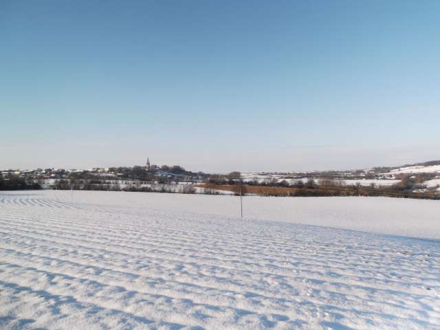
Despite an unexpected heavy snowfall which arrived during the late evening of Boxing Day, 8 members of the Club managed to negotiate the poor road conditions in time to arrive at the starting point of the ramble located outside the Junior School at Laughton to take part in the club’s annual visit to the Roche Abbey carol Service.
Our efforts were justly rewarded, for Saturday, 27 December 2014 had dawned with bright sunshine and clear blue skies that lit up the snow-clad countryside.
We set off with snow crunching beneath our boots, but we were soon making frequent stops to enjoy the breathtaking picture postcard scenes that unfolded along the way as we approached Roche Abbey.


Unfortunately, the traditional sounds of a brass band playing welcoming Christmas tunes and the serving of hot drinks on our arrival were missing this year due to the difficulties with the weather encountered by the organisers.
It was pleasing however to see and greet small parties who had arrived from other start points namely Maltby, Firbeck, and Laughton Churches and we were all soon tucking into tasty mince pies brought in by one of the organisers in his Land Rover. In addition he had brought along and quickly rigged up a PA system within the gatehouse of the Abbey, and although the congregation was much smaller than usual we all joined in the short service conducted by the Vicar of Maltby that gave us the opportunity to sing carols ably led by a lone trumpeter.
Our return journey back to Laughton was equally impressive with the snowy skyline dominated by the spire of Laughton Church.
Needless to say one or two of us had begun to get a muscular twinge or two brought about by the continuous tramping through the snow, and the return to our cars came along at just about the right time.
18th December 2014
On Thursday, 18 December 2014 our walk began in the secluded surroundings of Whirlowbrook Park just below the old Hall on a very dull and threatening day. As we walked up hill to the back of the hall the rain came down as a very fine drizzle. Undaunted, we took the path down to Whirlow Brook which we crossed turned left and followed up hill through the woods which gave us some shelter from the rain even though all the trees had lost their leaves . As we crossed back over the Brook we emerged out of the wood into open field and fortunately dry weather.
Our route took us over the fields to Ringinglow, past the Round House and the Norfolk Arms, behind which was a field of Alpacas sheep, down and down a steep muddy bank into the Porter Valley. There was a little excitement as we descended with a couple of our members slipping over, sometimes more than once. Our path was now a gentle descent all the way to Hunters Bar on excellent paths. A halt was made at the Dam Café, just south of Fulwood, where a number of our party enjoyed excellent bacon butties and cups of tea.
The final leg of our journey was along the banks of the river past the Sheppard’s Wheel and into Endcliffe Park. We had a short wait at Hunters Bar for the bus which took us back the entrance of Whirlowbrook Park and our starting point.
The walk down the Porter Valley is quiet and picturesque in spite of the fact that it passes well into Sheffield’s suburbs. It is well worth the trip and the walking is very easy.
30th November 2014
Aughton Lane – Ulley Reservoir – Ulley village – Carr Lane – Piper Lane (Aston) – Aughton Lane
The weather was unexpectedly pleasant as 20 Todwick Ramblers met at the bottom of Aughton Lane. We set off down the field to Ulley Reservoir. We walked round the reservoir and then up Reservoir Road, which was quite a steep incline, to arrive in Ulley village.
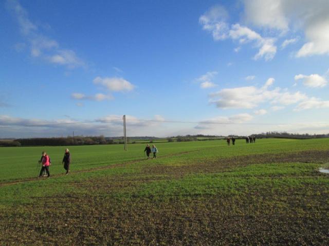

Unfortunately, we were too early for opening time so we sat on the picnic benches outside the Royal Oak and had our lunch. After lunch we walked through Ulley, along Carr Lane and across some fields where we encountered some very muddy footpaths which eventually took us to Piper Lane coming out on Worksop Road in Aston. Finally we walked down Aughton Lane, back to meeting point.
This was a pleasant walk for the end of November. It was 6 ¾ miles and took us three and a half hours.
Jenny Hudson
11th November 2014
Thrybergh Country Park – Ravenfield Church and Ponds
Despite early rain, 15 walkers assembled at Thrybergh Country Park ready to start the walk at 10 o’clock. We set off around the reservoir, but when we reached the far side we left the park and walked up a quiet lane towards Ravenhill. It was quite a steep hill and some of us were glad to stop and admire the views over Rotherham whilst we caught our breath!
After crossing a busy road we walked down a path and then up to Ravenhill Church, here we stopped for coffee and a look around the church yard. The church tower has a rare one fingered clock, unfortunately this was pointing to 3! As it was actually approaching 11 o’clock we assembled by the church steps and observed 2 minutes silence.
We then continued over a couple of stiles, across a field and down a narrow lane to reach Ravenfield Ponds. These ponds, popular with anglers, are set in a secluded wooded valley. We enjoyed a delightful walk through the woods, with views between the trees down to the lakes where we spotted a heron. There was even some watery sunshine. A bridge between two of the ponds provided ideal seating as we enjoyed our lunch.
Then a very sharp incline to take us back to the ponds entrance before we retraced our steps back to Thrybergh, completing our circuit of the reservoir when we re-entered the park.
A very pleasant and varied walk of about five and half miles, and fortunately good walking weather with no rain.
Gill Moran and Marion Brassington
14th & 15th October 2014 – Runswick Bay Away Jolly
Runswick Bay – Sandsend – Cleveland Way – Levisham village – Runswick Bay
Runswick Bay – old Whitby, Redcar and Middlesbrough Union Railway line – Kettleness – Runswick Bay
With some interest shown it was decided to organise a two-day away ramble. A suitable hotel was found at Runswick Bay. This gave the opportunity to catch the bus south to Sandsend and walk back along the Cleveland Way to Runswick Bay. We decided to do a short walk from Levisham village on the way up to Runswick. A 3-4 mile round walk had been plotted, taking in Levisham railway station and following the NYMR line to Newtondale Halt, there were warning signs about adders but no adder with any sense would have been out on a day like this. Six ramblers arrived at the start but only 4 + dog started to walk in heavy rain. The walk was slightly longer than anticipated but this was made up for by seeing several steam trains and a very impressive waterfall. Tuesday evening the eight of us ate in the hotel.

Wednesday dawned fair and sunny and, after a very good full English breakfast, 7 ramblers caught the bus to Sandsend. The bus was new and even had 13 amp sockets to charge your gadgets. The walk started on the old Whitby, Redcar and Middlesbrough Union Railway line. It was easy going and had great views of the coastline. The railway went through a tunnel which is now closed so ramblers have to climb some steep wooden steps but the going is pretty level after this with more great views and more tunnels. Our resident birdwatcher spotted a peregrine falcon soaring above the cliffs. We had lunch at Kettleness, perched on the cliffs overlooking Runswick Bay. The descent onto the beach at Runswick has good wooden steps, the last part being a bit tricky but no problem. For some reason some of the party ignored the handrail on the left and crossed over the stream resulting in one wet bum. One of the ramblers collects sea glass, so it was eyes down as we walked along the beach. One lucky member found a very nice ammonite fossil worth £20.
We had another good evening meal and discussed a walk north to Staithes for Thursday. Due to heavy rain common sense prevailed and we went our separate ways on Thursday after another full English breakfast. Thanks to the ramblers who came and hopefully we will persuade more next time.
Mick Barraclough
12th October 2014
Unstone – Ramshaw Woods – New Whittington – West Handley – Apperknowle
Todwick Ramblers enjoyed far-reaching views on their walk from Unstone on Sunday, 12 October 2014. The walk in warm, sunny weather climbed up through Ramshaw Woods to New Whittington and West Handley before crossing fields to Apperknowle where lunch was taken at The Travellers inn. The final section of the route descended through fields back to the start. Rebuffing claims that the walk was longer and steeper than the six miles published, walk leader Ken Whetter said that GPS on smartphones were notoriously unreliable, especially when switched off over lunch!
Ken Whetter
21st September 2014
Crich Stand Tower – Derbyshire Dales – Crich Tram Museum – Mill Green – Wingfield Park – Wingfield Manor – South Wingfield – Crich Church
On Sunday, 21 September 2014 a relatively small contingent of 8 ramblers arrived at the car park adjacent to Crich Stand Tower, to enjoy a ramble of approximately 7 miles through the rolling countryside of the Derbyshire Dales.
The walk commenced in lovely weather conditions, and on a literal high, due to the fact that our start point was situated on the highest point in the area at 286 m.
Opened in 1923, Crich Stand Tower is a war memorial dedicated to members of the Worcestershire and Sherwood Foresters Regiment who gave their lives in two world wars and other conflicts. It is beautifully kept, enabling the visitor to enjoy the magnificent views that surround the site. In addition, it has a small café that provides light refreshments and access to a panorama dial that gives clues about the distant horizon.
Leaving the Tower our route meandered downhill to pass by the Tram Museum and skirt the perimeter of Crich village, before picking up a footpath that took us to the hamlet of Mill Green. From here we tackled a short climb through woodland before descending via an ancient green lane to the few houses that remain of Wingfield Park.
Another short sharp climb took us to the brow of a hill upon which stands the magnificent ruins of Wingfield Manor. Originally built in 1450 for the Third Barron Cromwell, then Chancellor of England, it was later purchased by the Second Earl of Shrewsbury and was the design inspiration for Hampton Court Palace.
With the Manor ruins behind us we continued to descend to South Wingfield situated at 97 m by the River Amber and our halfway point of the ramble. Here the route now started to climb steadily via a collection of stiles and squeezers that gave us access to a landscape of woodlands, grassy meadows, occasional farmsteads, and pastures with cattle and sheep grazing as we gradually reclaimed the height of over 200 m before passing by Crich Church to return to our cars and a welcome hot drink and cakes in the café.
5th September 2014
Digley Reservoir car park – Blackpool Bridge – Holme – Digley and Bilberry
The walk started at Digley Reservoir car park, just a couple of miles up the valley from Holmfirth, Last of the Summer Wine territory.
The car park was in an old stone quarry, the track to the top of the quarry was a challenge but after this most of the ramble followed on comfortable well-used paths. The weather was excellent, very sunny and hot with good visibility to the masts of Holme Moss and Emley Moor and further to the power station at Ferrybridge. The moor still had good cover of purple heather and a few Red Grouse were disturbed to fly away low to new cover.
One break was at Blackpool Bridge by the stream in Marsden Clough. No idea why it was so named as a quieter, more peaceful spot would be difficult to find. The walk continued over moorland tracks to the little village of Holme, on the Le Tour route, then descended back towards the reservoirs.
The final part of the walk took us over the dam embankment between the reservoirs of Digley and Bilberry, through a little woodland plantation then back to our start point.
14 members had made the journey, just under an hour’s drive, and enjoyed a 6-7 mile ramble in what was for most a new location. The club has many local rambles but it is always a pleasure to visit new areas a bit more distant, we are fortunate to have such a wide choice of venues nearby.
Brian and Rosemary Chambers
22nd August 2014
Linacre Reservoir – Woodnook Lane – Ashgate Hall – Westwick Lane – Old Brampton – Linacre Woods
For our late August walk we again returned to Derbyshire, not the more popular Peak District, but the rolling farmland just west of Chesterfield. This area of lush green meadows enclosed with mature trees, hedgerows and crossed with small streams is arguably more scenic than the Peak District and a joy for walkers with good paths and gentle slopes.
With many of our members holidaying in such faraway places as Australia, Canada, Isle of Man, Scotland, and Scarborough, it was good to find eleven walkers at our starting point of Linacre Reservoir car park.
A short walk took us to our first stop, the toilets! These facilities provided by Yorkshire Water were well maintained and clean, justifying the £2.50 charge recently imposed for the car park.
Fully relieved, we proceeded along Woodnook Lane, initially a wide track through the woods, but soon becoming a narrow track between hedges which gave splendid panoramic views down over Chesterfield. After about 1 mile, we came to a minor road at Ashgate. Pausing briefly to admire the residence of football manager Danny Wilson, we crossed the road to go down a farm track at the side of Ashgate Hall. The Hall was built by one of the prosperous Chesterfield mine owners, but was then acquired by the NHS for a Maternity Hospital, and is now a hospice. As we walked down this track a number of narrow mature woods were seen down the field edges. These were planted by the first owner of the Hall to screen the distant Chesterfield to Baslow road from his view.
Crossing fields we then came to a bridge over a delightful stream, which winds its way down the valley to eventually become part of the River Rother. Crossing a further field we stopped for our first refreshment break, sitting on the grass, careful to avoid the evidence that cows had been grazing in the field.
Continuing through further fields, we emerged into Westwick Lane, which again gave good views down over Chesterfield to the Crooked Spire. One of our members offered the information that the spire was crooked due to the use of unseasoned timbers, however the leader being a Chesterfieldien by birth gave the true reason as being that one day a virgin bride entered the church to be married and the spire turned to look at this unusual event and has remained crooked ever since. It will only straighten up when the next virgin bride enters.
The lane soon became a rough track between hedges with further splendid views up the valley before dropping down to the stream we crossed earlier. Leaving the lane we followed a gentle uphill path to reach the Church at Old Brampton.
The village of Old Brampton straddles the road for about a mile and once enjoyed a good village community, but is now just another commuter village with the pub being closed, and services not held every Sunday at the church. Passing the church we dropped back down to Linacre woods to take our second break at the side of the top of the 3 reservoirs. At this point Yorkshire Water had provided picnic benches with good views across the water, which seated just our 11 walkers.
The rest of our walk was on well-maintained paths around the 3 reservoirs, through mature beech woods, and back to the car park, a walk of just under 6 miles.
Terry Calladine
8th August 2014
Todwick – Wales – A57 – Todwick Common Farm – Red Lion Hotel – Todwick
Six days later our next event was a 5 mile evening ramble around Todwick. Once again the dress of the day was distinctly summery as our 17 strong party meandered through the countryside. This was the scene of much activity with the farmers harvesting their cereal crops in the warm sunshine.
Our route followed the well-trodden paths that connect Todwick, Wales, and the outlying farms eventually directing us to the new upgraded A57. At this point we turned towards Todwick and rediscovered sections of the old A57 that have reverted into quiet backwaters which are now a pleasure to walk along.
Returning into the countryside close by Todwick Common Farm we eventually arrived at a junction of paths on the outskirts of Todwick. At this point the leader suggested two directional options. The first option led back to our start point, the other option was to take a short diversion finishing outside the Red Lion Hotel.
Given the dry and dusty conditions on the walk it was not surprising that the majority of the party chose to opt for the Red Lion, where a pleasant hour was passed very quickly prior to making our way back to Todwick under a harvest moon.
2nd August 2014
Bramley – Wickersley – Sensory Gardens of Winthrop Park – Wickersley Woods
The first two rambles which saw the commencement of the Clubs Autumn / Winter programme were local rambles that enjoyed good weather conditions. This was fortunate because both offered a food and drink option alfresco.
The first event that took place on Saturday, 2 August 2014 was a 4 mile mid-morning stroll taking in the countryside around Bramley and Wickersley, and having as its highlight a visit to the sensory gardens of Winthrop Park.
On completion of the first half of the ramble, which included views of Slacks Pond and the surrounding area, our party of 14 arrived at Winthrop Park. The sensory garden was a delight to the eye with plenty of interest for even the most casual of gardeners. However, it wasn’t long before a variety of tantalising homemade cakes and a range of hot drinks tempted our party to visit the very pleasant café within the grounds of the garden.
After enjoying a relaxed hour our party continued the ramble to pass through fields of ripening corn before exploring the shady paths of Wickersley Woods. Once out in the open again we became concerned about a large black cloud that had appeared on the horizon. Fortunately, we made it back to our cars before the heavens opened.
21st July 2014
Cresswell Crags – Welbeck Estate – Worksop Manor – Belph – Cresswell Crags
On Monday, 21 July 2014 thirteen club members arrived at the Cresswell Crags Visitors Centre to explore the Nottinghamshire and Derbyshire countryside that surrounds this famous location. The weather was ideal for walking with sunny blue skies and just a hint of breeze to keep us cool.
We commenced our day by following a well-defined path system that included a tree-lined bridleway, tracks through open fields and mature woodlands, pausing after about an hour to admire two attractive lakes situated on the perimeter of Welbeck Estate.
With glimpses of the Abbey in the distance our route now followed the line of one of the tunnels created by the reclusive Duke of Portland. The tunnel eventually terminated at a castellated gatehouse which provided a pleasant backdrop for our coffee stop.
Our journey now continued at a leisurely pace through the landscape of fields and woodlands, stopping briefly at one point to admire the impressive façade of Worksop manor, before eventually arriving at the outskirts of the hamlet of Belph.
With over 6 miles completed we were ready for a rest and a drink. Conveniently situated nearby we came across the Penny Hill Cafe, which served our purpose well.
After a very enjoyable picnic break within the gardens of the cafe we set off rejuvenated to complete the remaining 1½ miles back to the Cresswell Crags Visitor Centre.
Jim Tompkin
13th July 2014
Aston Lane – Falconer Lane – Treeton Dyke – Treeton Woods – Treeton Lane
On Sunday, 13 July 2014 15 members and friends met at the bottom of Aston Lane at 10.00 am.
At first the weather did not seem too promising but we remained optimistic and were rewarded with a gradual improvement throughout the walk. We headed off down Falconer Lane to arrive at Treeton Dyke. It is a pleasant, level walk but there were no water skiers on the dyke to enhance the interest. We stopped for a 15-minute coffee break then continued round the dyke.
The last part of the walk was through Treeton Woods which was quite a steep incline. (Everyone was forewarned!) This then brought us out onto Treeton Lane which was a 10-minute walk back to the cars.
The walk was steady and took 2 hours. I classed it as a 5-mile walk but was probably on about 4.5 miles.
Jenny Hudson
26th June 2014
Five Churches walk – Axle Lane – South Anston Church – Chesterfield Canal – Thorpe Salvin Church – Loscar Woods – Harthill Church – Wales Church – Manor Lane – Upper Common Farm – Goosecarr Lane – Todwick Church
On Thursday, 26 June 2014 six intrepid ramblers set out from Todwick Church car park to cover the ten miles of the Five Churches Walk. We left at 10.00 am on a perfect spring day.
Our route took us down “Piggy Lane” past the Manor House and out onto the fields across to Axle Lane in South Anston and through the village to the church. From South Anston we dropped down onto the banks of the tranquil and picturesque Chesterfield Canal and then up into Thorpe Salvin past church number two.
Off we went to Harthill via Loscar Woods and church number three but more importantly a meal and a pint of the local brew in the Beehive.
Refreshed, we set off again to Wales via Kiveton Country Park and church number four. The last leg was down Manor Lane and along the footpath to Upper Common Farm and thence to Goosecarr Lane. Returning home to Todwick, church number five, after a splendid walk on a perfect day.
Neil Hawksworth
8th June 2014
High Moor – Hut Lane – Killamarsh – Rother Valley Park – Cuckoo Way – Church Lane, Wales – Storth Lane – Todwick
Taking the opportunity to make use of it before it is discontinued, 16 walkers “flashed their passes” at the driver on boarding the 29A bus to Mansfield Road, High Moor.
On alighting, we were joined by a further walker making a happy bunch of 17 as we began our walk in lovely sunny weather with a stroll down the curiously named Hut Lane in this little corner of Derbyshire.
Shortly we encountered the first of a number of substantial stiles constructed from rail sleepers. Climbing over this we left the lane to cross the first of a number of small fields contouring the side of this pretty valley to emerge between houses in Killamarsh.
Passing the Crown Inn, a number were tempted to follow the delicious smell of Sunday Lunch cooking, but as we walked on the leader was surprised to find the head count was still 17.
Shortly we entered Rother Valley Country Park to walk alongside the fishing lake where the ground was very wet underfoot from all the recent rain. One of our walkers complained that her boots were letting water, resulting in wet feet. (Come on Mick don’t be so tight, buy your wife some new boots.)

On reaching the wildlife lake we stopped for our first refreshment break with delightful views over the lake. Unfortunately there was only one “5 bottom” seat, so the other 12 walkers had to sit on the grass.
Fully refreshed we continued through the park to reach the main entrance, crossing the road to join the Cuckoo Way. Passing a number very pretty ponds and canal-side cottages we climbed up to just below the motorway were we took our second refreshment break.
Negotiating the motorway through the underpass lead us via further field paths to Church Lane, Wales, and our route back to Todwick along Storth Lane.
Terry Calladine
25th May 2014
Cannon Hall – Jowett Hall – Deffa Wood – Wheatley Hill Farm – Swallow Hill – Hoyland Hill – Margery Wood – Barnsley Boundary Walk – Cawthorne Dyke – Cannon Hall Country Park
Sunday, 25 May 2014 provided weather that consisted of leaden skies with the threat of more rain to complement the downpours of the previous day. Despite the inclement weather 14 ramblers arrived at Cannon Hall car park to brave whatever ‘Mother Nature’ desired to bestow on us.
Ignoring the dull damp conditions the group set off along a good farm track to pass by Jowett Hall, before turning off to access a meadow via the first of the 29 stiles we were to encounter along the walk. Immediately, our boots became immersed in the saturated land with deep mud and puddles waiting to catch the unwary. This meadow proved to be typical of the farmland we were to walk through over the next 4 hours or so.
Fortunately the early part of our route incorporated a gentle climb of approximately ¾ mile in length that used good tracks through Deffa Wood, where rhododendrons were blooming despite the weather. Still gaining altitude, and now enjoying magnificent views we passed Wheatley Hill Farm to reach Swallow Hill, the highest point of our day at 160 m. This proved a good place to stop and enjoy a welcome but soggy picnic lunch.
The hamlet of Hoyland Hill was our next point of call from where we could see Cawthorne and Cannon Hall far below us in the distance. Continuing steadily downhill we followed waterlogged tracks through Margery Wood to link into a muddy section of the Barnsley Boundary Walk, before crossing and following Cawthorne Dyke as it meandered through Cannon Hall Country Park, where the rain finally caught up with us.
Looking rather wet and bedraggled but full of high spirits we returned to our cars to take the short ride back home where a welcome hot soak and a well earned hot meal would complete an enjoyable day out.
Janet Tompkin
11th May 2014
Anston – Anston Stones Wood – Rackford Lane – Dewidales Wood – Lindrick Common – Golf Club Tunnel – Monk’s Bridge – Moses Seat Wood – Lindrick Dale
On Sunday, 11 May 2014 twelve Todwick Ramblers ignored the rainy weather forecast and reported to Anston Parish Hall car park for a 10 o’clock start. The walk took us through Anston Stones Wood and across the adjacent meadow to Rackford Lane. The sky was overcast but not making any rain.

The walk then continued to Dewidales Wood and then south along the path towards the A57, here we had a short sharp 3-minute shower. After a little shelter we continued along Lindrick Common, across the Golf Course then followed the concessionary footpath through the Golf Club Tunnel below the A57, eventually rejoining the footpath towards Monk’s Bridge.
Following refreshments we continued through Moses Seat Wood, around the Lindrick Quarry and into Lindrick Dale, by now the sun was making an appearance. Then it was back across a busy A57 and into Anston Stones Wood. The walk was then completed as we followed the lower path through the wood and back to the car park. A few clambered up the steep slope to view Dead Man’s Cave. A good 6+ miles walk with bluebell carpets and wild garlic amongst the flowers to appreciate.
23rd April 2014
Monsal Hill – River Wye – Cresswell Tunnel – Litton Tunnel – Tideswell Dale – Brushfield Hough – River Wye
Wednesday, 23rd April 2014 provided a warm, bright, pleasant but cloudy day for fifteen intrepid ramblers who met at Monsal Head.
Our walk took us down a steep path onto the viaduct crossing the River Wye which now carries the Monsal Trail. The trail runs along the line of the old railway which ran between Bakewell and Buxton and we followed it in a westerly direction. The old railway track has been removed and a tarmac surface lay in its place, so walking is very easy. As we walked along we had superb views over Monsal Dale with the River Wye flowing in the bottom.
After a short time we passed through Cresswell Tunnel which is one of a number of railway tunnels recently opened after being repaired. Lights have also been fitted to allow safe passage of walkers. Emerging into the sunlight we had views over Water-cum-Jolly prior to entering Litton Tunnel and eventually to the path leading up the hill above Litton Mill. This was quite a steep pull but we all managed it whilst admiring the profusion of Wood Anemones.
From the top of the hill we dropped into the lush green of High Dale, with its sides covered in newly emerging cowslips, which we followed eastwards into Tideswell Dale. Keeping high away from the main road we passed through Brushfield Middle Farm where the buildings have been converted into lovely holiday cottages. Our journey then took us over the fields to Brushfield Hough from where we dropped down through the woods down into Monsal Dale.
We then followed the River Wye upstream on its west bank eventually crossing the footbridge just downstream of the weir. From here our way took us gently uphill back to Monsal head and a welcome ice-cream.
4th April 2014
Whiston to Wickersley circular
13 walkers met in the car park of the Sitwell Arms in Whiston for a walk jointly led by Marion, Audrey and Gill.
We set off soon after 10 o’clock to walk through the village beside the stream and then up a narrow footpath to the church. At the church we stopped to look at the stocks, the lynch gate built as a war memorial and one of the gravestones with an interesting carving and epitaph.
We walked up Doles Lane, with good views across the surrounding countryside, a field path then took us across to Royds Moor Hill. After a short walk along the road we turned in to Pinch Mill Lane, a quiet lane leading to the fisheries and farm, we stopped here for a drink, then uphill again to Wickersley. We walked through the housing estate, enjoying the Spring flowers and giving gardens marks out of 10. We stopped for lunch at the bottom of Sledgate Lane where we could enjoy wide views across Rotherham and the surrounding countryside. We continued on field paths, fortunately not too muddy, back to Whiston, skirting Sitwell Park Golf Course, downhill most of the way.
A pleasant leisurely walk in a surprisingly green and rural area, which is so close it is often overlooked, some of the paths were new to many of the walkers. Although it was misty the sun did break through from time to time and we escaped without any rain, so enjoyed a pleasant day.
Janet Tompkins
23rd March 2014
Hardwick Hall – Teversal Trail – Newbold Mill Lane – Teversal Trail – Rawthorne Trail
A bright sunny morning welcomed us at Hardwick Hall the starting point for our latest walk. However, just as the 20 walkers were attired in their walking gear and gathered ready to commence walking, a black cloud appeared and a heavy rain and hail storm forced shelter to be found under a large tree.
Thankfully, the rain quickly cleared and left us with yet again a bright sky which remained throughout the rest of our walk, which started with a pleasant stroll through Lady Spencer Wood and out of Hardwick to join Norwood Lane.
After a short distance along this delightful lane we crossed a field path, and followed a boundary hedge to gain access to the Teversal Trail. This trail is one of many former rail lines which served the coal mines in this corner of Derbyshire and Nottinghamshire. The mines having been closed for many years, the trails now serve as a labyrinth of paths not only for walkers, but cyclists and horse riders.
20 minutes walking south along this trail brought us to the “highlight” of our walk, Teversal Visitors Centre, or to be more precise a resting place, plus tea, coffee, and bacon butties all at very reasonable prices.
Fully refreshed, we continued along the Link Trail and then up a field path to Teversal Village and past the grade II listed seventeenth-century Teversal Manor, on the market at present for £1m. The manor was the inspiration for Wragby Manor in D. H. Lawrence’s novel Lady Chatterley’s Lover. Lawrence took regular walks through Teversal from his nearby home in Eastwood and called the village Teversashall in the novel.
Leaving the village via the Manor drive lined each side with daffodils fully in flower; we crossed a number of fields through beautiful rolling countryside, never being quite sure if we were in Derbyshire or Nottinghamshire as we kept crossing the boundary. This took us on to Newbold Mill Lane and back to the Teversal Trail, at which point, those wishing for a shorter walk of 5 miles (some said the less fit, but I pass no comment) returned to Hardwick.
The “fit ones” then continued along the Teversal Trail, but now in a northerly direction, for our second stop just before turning off on to the Rawthorne Trail.
This trail now took us to the Rawthorne Gates of Hardwick Park and up past the Hall, the new visitor centre, and back to the car park to complete the full walk of just over 8 miles.
Terry Calladine
9th March 2014
Elsecar Heritage Centre – Trans Pennine Trail – Oldmoor Wetlands Centre (RSPB) – Elsecar
On a bright and sunny spring morning, 17 members started a 6-mile walk from the Elsecar Heritage Centre. The centre was originally developed in the 1700s and 1800s by the Earl of Fitzwilliam as a coal and ironstone community. We then walked along the Elsecar Canal which was built to transport coal and iron to the main Sheffield to Hull canal.
We then continued along the Trans Pennine Trail which is a path which you can walk from Liverpool to Hull. This trail is part of the E8 trail – a path which continues right to Istanbul in Turkey.
We then headed towards Oldmoor Wetlands Centre (RSPB) where a welcome refreshment stop was made.
Fully refreshed we returned to Elsecar by a different route.
Anne Rusling
17th February 2014
Hope – Grindleford – Shatton – River Noe – Leadmill Bridge – Upper Padley – Hope
Ten Todwick Ramblers met on Parsons Lane at Hope for the riverside walk to Grindleford, eight arriving by car and two by train. The first stone stile proved a test for the Ramblers with short legs but all got over safely. With the ground being very wet the climb across a sloping grass field was testing but no fallers yet. Looking back we could see Win Hill and Lose Hill with both tops shrouded in low cloud. The going was easier now as we walked on a farm access road then took a deserted footpath to Shatton. On leaving Shatton the path follows the river (The River Noe which joins the Derwent just before Hathersage) most of the way to Grindleford, the going gets harder and we had a faller on the very slippery mud but no harm done. In several places the streams coming off Offerton Moor were in full flow, the plank bridge over one of these needed extra care as it is open on one side.
After walking two miles a vote was taken and by a margin of 9 to 1 this became the coffee stop. For a while the walking got easier across flat fields but this did not last long as the path moved nearer the river. For anybody who knows this area but has not been there for a while the Marquess of Granby has now been completely demolished.
By the river the path is like a roller coaster up and down and very slippery, luckily the downs had fences to hang on to. Once past this the path narrows to single file and is very tricky, a number of Ramblers went over the fence onto the farmer’s field, names have been noted. Lunch stop was at the side of Leadmill Bridge on the A6001 from Hathersage, some stone blocks made good seats. After crossing the main road the path is on a private road leading to a very nice stone house set on its own.
Scattered at the side of the road are a variety of dressed stones, these are possibly from an Ice House. After this we crossed a partly flooded meadow and into more water and mud another faller here (sorry Tripper) but again no damage done. At this point we had a change of walk leader and took the high road over the railway bridge and onto the track that leads to Upper Padley. We stopped to look at the incline where the stone for the Derwent Dams was brought down to the main line then taken to Bamford before being put on the purpose-built line that took it to the Dams. The group arrived just in time for the two train travellers to grab a tea and rush off to catch the Sheffield-bound train into the three-mile-long Dore and Totley Tunnel.
The others went into the café, as we had 45 minutes to wait for the train back to Hope. Several people had massive chip butties, no names mentioned here. Our train back was on time but could not set off because of a faulty switch on the door that stopped the brakes being released. After some muttering by the conductor and opening the doors a few times it decided to go and we made our way back to Hope station.
Thanks to all the Ramblers who turned up and made it an enjoyable day out.
12th January 2014 – Local Walk
Chesterfield Canal tow path Cuckoo Way – Thorpe Top Lock – Lindrick Dale – Aston Common Farm – South Anston – Axel Lane – Todwick
On a very pleasant sunny but frosty morning 24 walkers met at Todwick News for our latest local walk the route utilising yet again the always tranquil Chesterfield Canal tow path, known as the Cookoo Way.
Our planned route on the path over the fields and Kiveton Quarry recycling plant had to be diverted due to yet again the path through the quarry being ankle deep in slurry from the lorry wash. (A problem that has seen action many times by the club, but still reoccurs).
After a gentle stroll along the tow path we stopped for our refreshment break at Thorpe Top Lock.
Fully refreshed the walk then left the canal to pass over fields to Lindrick Dale, through Aston Common Farm, and around the side of the quarry to emerge in South Anston.
Our walk was completed along Axel lane to return to Todwick.