Todwick Ramblers Club Walks: 2017
27th December 2017
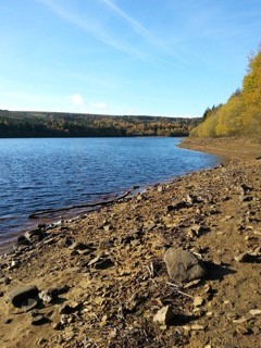
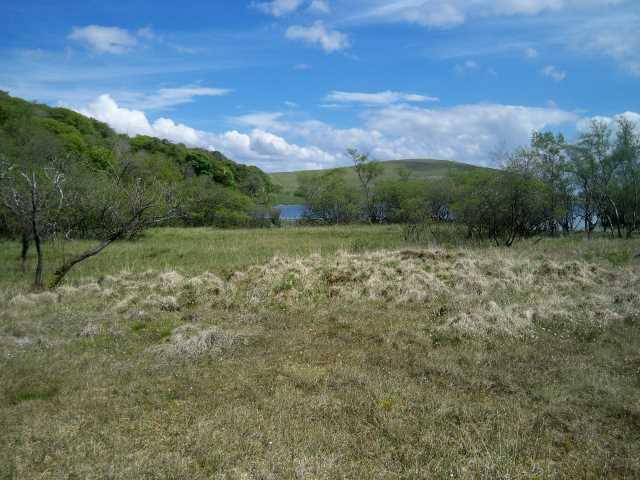
Todwick Ramblers ‘Betwixmas’ Ramble – Rother Valley Country Park – Bedgreave Mill – Main Lake – Trans Pennine Trail – bridge over the River Rother
As soon as daylight arrived the weather deteriorated, to give a soggy wet landscape with a brief snow blizzard descending at 10.00. This happened to coincide with the time that the intending participants in the Betwixmas ramble were due to leave home.
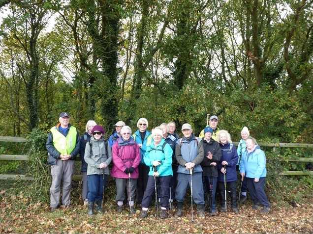
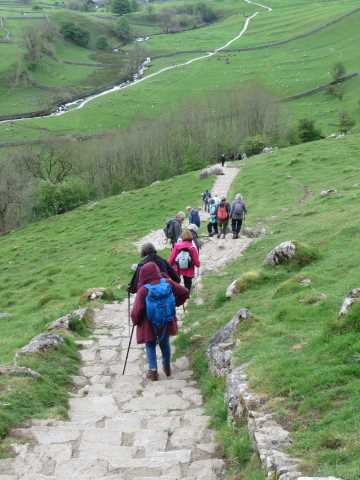
Despite this discouraging start, eight ramblers set off at 10.30 to complete a 5-mile circuit around Rother Valley Country Park. However, after approximately 15 minutes had elapsed, we increased our number as another rambler caught us up, after making a late decision about the weather forecast.
After a steady climb up a tree-lined track we reached a point where we were rewarded with a bird’s eye view of RVCP with its lakes, river and woodlands. From here we descended a broad rough track to the café at Bedgreave Mill where welcome hot drinks were taken, along with hot mince pies provided by Sue Turner.
Our journey continued in warmish sunshine as we followed the perimeter of the Main Lake, before picking up a disused railway line on the far side which is now a section of the Trans Pennine Trail. We used the Trail to negotiate through woodland, further lakeside paths, and a bridge over the River Rother before branching off to climb a path that returned us to our vehicles.
As we changed out of our walking boots our little group looked back over the last 3 hours since starting the ramble. Needless to say, we had all been pleasantly surprised regarding the swift change for the better in the weather conditions, proving that the English weather is a very fickle item to forecast accurately.
Jim Tompkin
Walk Leader
7th December 2017
Christmas visit to Hardwick Hall
Following early morning rain, 17 Ramblers arrived at Hardwick for a “Christmas at Hardwick” day. The weather report had suggested that any early rain would recede for the walk and this proved to be the case. Before starting the walk a new potential Club member, Carol, was introduced to us all.
The walk took us through a mixture of woodland and fields, often quite muddy in places, this being a marked contrast to the pre-walk done a week earlier when the ground had been firm with some frost around. One pleasing factor was that no cows were encountered on the walk, unlike the earlier pre-walk, much to the relief of some of our lady Ramblers present. A short coffee stop was made after a couple of miles when an attempt was made to get into the Christmas spirit by us all singing Rudolph The Red Nose Reindeer. The least said about the offering the better! We arrived back at the car park after about 2 hours having covered 3.5 miles around some of the beautiful Hardwick estate parkland.
After removing muddy boots, etc., it was off to the café for lunch before taking a short stroll to the Hall to view the Christmas decorations. The theme this year was Christmas carols and songs. As we entered the Hall we were greeted by a group of young school children singing Christmas songs in the Main Hall. Their singing certainly put our earlier attempt to shame. The displays around the Hall were beautiful and a great deal of time and effort must have gone into making them. After leaving the Hall some of us had a walk through part of the garden on the way back to the car park. A really enjoyable day and certainly one to get us all into the Christmas spirit. Many thanks to all who came along.
Ernest and Judy Wraith.
24th November 2017
Langsett Barn – Little Don – Mickledon Beck – North America farm – Langsett Barn
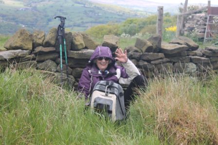
The forecast was for cold, frost and a stiff breeze but eight Todwick Ramblers arrived at the Langsett Barn car-park for the reservoir and moorland walk on Friday, 24 November 2017. However, we were rewarded with a pleasant sunny morning and a slight breeze.
We started with a pleasant stroll through woodland bordering the lake, only interrupted by a Mick search for Geocache sites. Next was a steady uphill climb from the bridge over the Little Don, here a fish ladder was under construction, taking us onto the moor.
The path continued up Mickledon Beck before turning back towards the reservoir. The snacks were taken here whilst appreciating the views northwards over the moorland towards the Woodhead road. The downhill path was a slippery slope over muddy and rocky terrain which was completed without upset and accompanied by many Red Grouse sightings. The derelict North America farm was passed, this was an area used for tank practice during WWII and unexploded ordnance is still a hazard. A winding unclear path was followed back through more reservoir-side woodland to reach the roadway back over dam wall and a return to the car park.
A very pleasant 5+ mile ramble over what is mainly Yorkshire Water managed land.
19th November 2017
Laxton and Holocaust Centre
A short walk of just over two miles around the village of Laxton was enjoyed by 25 members on a cold and initially frosty Sunday morning bathed in Autumn sunshine.
Starting from the Visitor Centre car park we walked through the village past the twelfth-century church before taking to an overgrown and muddy path to then cross into open countryside. A brief stop gave an opportunity to take in views to the east including Lincoln Cathedral whilst to the west we looked over Mill Field part of the open field system of farming still used in the village which is part of the Crown Estate.
We continued along grass paths and descended to the west of the village and completed our walk through Laxton passing the Pinfold and back to the car park.
Our transfer to the Holocaust Centre was completed in good time to partake of a light lunch before a presentation and tour around the centre which was both informative and thought provoking.
Keith & Wendy Eyre
Walk Leaders
11th November 2017
Ewden valley – More Hall Reservoir – Broomhead Reservoir – Ewden Village
Despite my misleading directions, 13 ramblers found the starting point for this walk at the dam wall of the More Hall Reservoir. We set off across the dam wall to the far side of the reservoir, then took the path up into and through the woods. A most attractive walk with the sun highlighting the autumnal colours of the beech trees. There was a short stretch along a quiet lane before we crossed the lane to follow another path, this led to the dam wall of the Broomhead Reservoir, we had a brief stop here for coffee. The path then followed the edge of the reservoir, initially a wide track and then through trees with a lot of roots crossing the path. We realised that it was now past 11 o’clock, but stopped for a minute so that people could remember quietly. We continued along the path until briefly taking to the road to cross Broomhead bridge at the head of the reservoir.
Then we were on the north side of the reservoir, still following a path through trees but now enjoying bright sunshine. It was so pleasant in the sun that we decided to have an early lunch on the shore of the reservoir. Despite the fact that it was November, it was almost like being at the sea, though rather rocky and unfortunately no ice cream!
After lunch we continued beside the water, then through Ewden village and along a quiet road on the North side of More Hall Reservoir, back to our cars. The walk was just 5 miles, made very enjoyable by the glorious weather and good company.
Marion Brassington
21st October 2017
New Bolsover – Stockley Trail – Carr Vale Flash wetlands – Sutton Scarsdale Hall – round walk
On Saturday, 21 October 2017, sixteen walkers met at New Bolsover for a walk across the M1 corridor to Sutton Scarsdale on the far side of the valley. New Bolsover is a “Model Village” of 200 houses built by the colliery owners for their workers families in 1896. Within the village were a school and a Co-op whilst on the outskirts were allotments and a cricket field. A typical philanthropic venture of the time, now being regenerated at a cost of over £10m.
The walk took us along the Stockley Trail, a former railway line, past Carr Vale Flash wetland reserve and then a bit of a route march across farmland towards the M1, passing the supposedly haunted ruins of Lodge Farm. Across the motorway a steady climb brought us to the ruins of Sutton Scarsdale Hall, which many motorists will recognise as “what’s that up there on the hill”. English Heritage now own the Hall and hope to secure the building and make it safe for visitors.
More route marching and a final pause to read a plaque to Peter Fiddler, a local lad, who at 19 went to Canada in 1788 and became Canada’s Captain Cook.
A stiff walk of 6.1 miles but some terrific viewpoints.
Nige and Jude Singleton.
8th October 2017
Rivelin Valley
On a fine morning 20 Ramblers, including 2 new members, gathered near Rivelin Post Office.
The walk took us into the Rivelin Valley for a short distance before crossing Manchester Road to join a broad track which climbed steadily towards Cross Pool. On old maps there is no Manchester Road, no Rivelin Valley Road, just this track labelled “The Road”. We then descended back to Manchester Road at what used to be the Bell Hagg Inn, now a 7-bedroomed house.
Through ancient woodland and skirting quarries, we descended to Rivelin Park and the “Pudding Ladies Cafe”. After lunch the walk took us alongside the river back to our cars, passing many small dams, the remnants of early industry and the beginnings of Sheffield steel which made use of the water power.
The 4.5-mile walk had given us some amazing vistas and within a couple of miles of the city.
Nigel and Judith Singleton
Walk Leaders
21st September 2017
High Lane – Moss Valley – Ridgeway – Robin Lane – Ford
The walk on Thursday, 21 September 2017 took thirteen members of the Todwick Ramblers over rolling countryside from High Lane above Mosborough down to the Moss Valley and back. Using cross-field paths and farm tracks offering long-distance views, the group skirted the village of Ridgeway, resisting the temptation to visit the Swan Inn, and proceeded via Robin Lane, Carterhall and Sloadlane to our lunch stop at the Bridge Inn, Ford.
Over lunch, Ernest reminded people about the Xmas lunch booked for December and to let him know, if they have not already done so, if they wish to attend. Matt announced the imminent landmark birthdays of Margaret and Anne and thanked people for their good wishes.
The threatening rain, which had held off until lunch, descended with a vengeance as we set off again. Fortunately, the final stage of the walk was comparatively short and mainly on good, well-surfaced farm tracks. So, we ended the walk, which was just over 5 miles, a little wet but grateful that the weather had not spoiled too much the enjoyment of the walk.
I forgot to take any photos of the walk so I’m afraid people will have to rely on their memory and imagination.
Ken Whetter, Walk Leader
10th September 2017 – Charity walk from Creswell Crags
Creswell Crags – Holbeck – Holbeck Woodhouse – Creswell Crags
On Sunday, 10th September 2017, twenty-three adults and three children met in the car park at Creswell Crags for the second Friends and Family Charity Walk. This year’s chosen charity was The British Heart Foundation. The weather was overcast but dry, although showers were forecast for later in the day.
The start of the walk took us past the Visitors Centre and through the Meadow, passing the Children’s play area and Picnic area, before entering the Crags. The Crags is a wooded limestone ravine and is renowned as one of the earliest places of human habitation in Britain. It was here during the last Ice Age some 50,000 years ago, that prehistoric man roamed. In the caves that line both sides of the gorge, archaeologists have discovered stone tools and the remains of animals such as bison, mammoth and reindeer.
Leaving the gorge, we climbed up a steep path to enter a grassy area. A great view of the surrounding countryside was possible from this vantage point, including the site of the old Creswell pit. The walk continued through a number of fields, many of them lined with blackberry bushes which some of our group found far too tempting to just pass by! At the end of the fields we entered the small village of Holbeck where the first coffee stop was taken. Suitably refreshed we continued along minor roads to the village of Holbeck Woodhouse before making our second coffee stop by St Winifred’s church. This church was built in 1913 to serve the family, tenants and estate workers of the Duke of Portland. Some of our group decided to wander around the churchyard where the graves of many of the Portland family can be found. Lots of the graves were brought here from their original burial place at nearby Welbeck Abbey after the church was built.
Before leaving the church the raffle was drawn. The winners were:
Children’s prize
- Darcy – Cuddly toy
Adult prizes
- Rosemary Chambers – Bottle of white wine
- Jenny Hudson – Box of chocolate biscuits
- Matt Meek – Bottle of red wine
- Jean Knowles – Box of chocolates
Leaving St Winifred’s Church, we followed roads to return to Creswell Crags, stopping to see the Canadian War Memorial as we were about to enter the car park. It was close to here where 5 Canadian air crew lost their lives during the Second World War, the Memorial being a tribute to their bravery.
The walk distance was approximately 3.5 miles and a special mention should be given to the 3 children, Oliver, Max and Darcy, who completed the walk. Many thanks to all who contributed to the charity, including some who donated although unable to attend. Also to Elaine Margrave for supplying the children’s raffle prize. The total money collected was £168.
Ernest and Judy Wraith.
12th August 2017
5.5 miles Hope Valley circular – Castleton – Peakshole Water
On Saturday, 12 August 2017 a small but select group of ramblers numbering nine in total set out from Hope village, with the sound of the church clock striking the hour, giving us encouragement to ignore the black clouds overhead that had been forecast to dissipate around 11.00 hrs.
Leaving the village behind us we quickly encountered the lush grassy meadows full of sheep which are a feature that define this part of the Peak District.
Using well-trodden footpaths, we meandered along, passing from one field to another quite easily by using the pedestrian gates provided along the route, and enjoying the scenic backdrop to the walk that was provided by the hills all around us.
All too soon we began to approach the outskirts of Castleton which was the half way point of the ramble. On entering the village we discovered that a number of charming old stone cottages had been converted into jewellery and antique shops encouraging our group to participate in some retail therapy for a short while. However, we all managed to keep our monies safe in our back pockets and using quiet back streets we soon left temptation behind us as our route turned back towards Hope.


Before long we were soon walking once again through typical sheep country split up into fields but this time by stone walls. We used an interesting variety of gates and stiles to pass from one field to another with the chimney of the cement works providing a constant brooding landmark, before returning to our cars via a footbridge over a broad stream known as Peakshole Water.
Generally, the weather was reasonably kind to us despite two short showers which coincided with our refreshment stops.
An extra bonus on the day was the sight of the heather on the moors in full bloom as we travelled between Fox House and Hope along the A625.
26th July 2017
Chander Hill – A619 – Bagthorpe Lane – Wadshelf – A619 – Chander Hill
Despite the weather forecast for heavy rain, 21 enthusiastic (or should that be foolish?) walkers met at Chander Hill on the west side of Chesterfield.
Crossing the A619 we entered fields by the first of many challenging stiles, made even more difficult by the wet conditions.
Four fields, a river bridge and a short muddy climb took us out into Bagthorpe Lane and easier walking for a little distance.
Passing two typical Derbyshire farms we left the lane to walk field paths passing a boggy area which, along with another slightly further south, is claimed by locals to be the source of the river Rother.
We soon reached the Hamlet of Wadshelf, named after Wadda who lived here on a ledge or shelf. Wadshelf was also once the home of the late Radio Sheffield presenter and folk singer Tony Capstick.
Again crossing the A619, we continued along field paths which normally give splendid views over Chesterfield, the Crooked Spire, and Bolsover Castle in the distance. Unfortunately, due to the rain clouds, none of this could be seen. Further field paths, two woods and a short road section took us back to our starting point. A short walk of 4.5 miles, but it seemed a lot further due to the rain and wearing of waterproofs. Thanks to all who made the effort to walk in the difficult conditions.
Terry, walk leader.
9th July 2017
Worsbrough – Queen Anne’s Obelisk – Rockley Furnace – Norman Church – Worsbrough Mill
On Sunday, 9 July 2017, sixteen members of the Todwick Ramblers group enjoyed a 5.5-mile walk in the countryside around the Worsbrough Mill Country Park. In warm and sunny conditions, the group followed a route which included paths around the reservoir, across fields, in woodland, some short road sections and through the small attractive village of Worsbrough before returning to the reservoir and visitor centre cafe and picnic area where many of us enjoyed tea and soft drinks to refresh us after our exertions.
A particular feature of this walk were the historical landmarks we passed on our route. These included: Queen Anne’s Obelisk, built in 1734 by Thomas Wentworth, first Earl of Strafford; the impressive ruins of Rockley Furnace, built around 1700 to smelt local iron ore and next to it an engine house from around 1813 to drain local ironstone mines; a Norman church with a number of medieval monuments; and, at the beginning and end of the walk, the 17th-century Worsbrough Mill which is now an interesting museum.
Ken Whetter
23rd June 2017
Cote Green Farm – Wharncliffe Escarpment – Howbrook – Wortley Hall – Wortley Village
With the sky threatening rain an intrepid band of 10 ramblers gathered at Cote Green Farm car park and began the ascent across the Wharncliffe escarpment. The higher we climbed the better the weather became. At the highest point of the walk extensive views were to be seen across South Yorkshire.
After a short break for coffee we began our descent over undulating countryside to the village of Howbrook, pausing to admire a particularly beautiful cottage garden. After lunch at the village wayside cross we continued on to the parkland surrounding Wortley Hall, through Wortley village and down the hill back to the car park.
Total distance was approximately 5.2 miles.
David J Warburton
Walk Leader
11th June 2017
Crowgate Car Park – South Anston – Chesterfield Canal – Hawks Wood – Old Spring Wood – Lindrick Dale – Anston Stones Wood – South Anston – Crowgate Car Park
On a bright but blustery morning, 18 members met at Crowgate car park, South Anston, for a local walk.
Initially going through part of South Anston we were soon out into open countryside, crossing fields down to the Chesterfield canal. Turning left we followed the canal for about 1/2 mile before leaving the canal and going into Hawks Wood, the first of 3 woods we would walk through. A steady climb took us to the top of the wood from where views of the Old Hall at Thorpe Salvin could be seen. A few weeks earlier the wood had been a carpet of bluebells, sadly all now finished.
The next wood was Old Spring Wood which eventually took us back to the canal where a coffee stop was made on one of the bridges over the canal. We were very fortunate that just as we arrived at the bridge a narrow boat was passing by making its way through the nearby locks.
Passing over the railway lines and a field took us into Lindrick Dale and then to Anston Stones Wood where lunch was taken. Suitably refreshed a steady walk through the wood followed where some of our lady members were particularly interested in some of the wild orchids growing there. Crossing the busy A57 road took us back into South Anston and the car park at Crowgate, a distance of 5.7 miles. Many thanks to all who attended the walk.
Ernest and Judy Wraith.
28th May 2017
Elton – Dale End – Cheese Factory – Smerril Grange – Long Dale – Gratton Dale – Oddo House Farm – Elton
Our walk started at the picturesque village of Elton a couple of miles west of Winster. Both villages are well worth a visit if you are ever in the neighbourhood.
The weather was warm and pleasant as 17 ramblers set out from the church down a lane and into the fields. The path dropped down towards the road going north from Elton to a gate in the corner of a field where we encountered a herd of cows blocking our way. In the midst of the cows was a rather large bull. We approached rather gingerly along the fence and they politely moved away to let us through.
We passed over more fields to Dale End and then onto the road to Smerril Grange. On our way we passed a house named the Cheese Factory where our arrival was announced by a noisy sheep dog. We then had a bit of a climb to the top of the hill where we passed some strange carvings on a couple of large boulders. Our group then arrived at Smerril Grange and took a well-earned break for coffee before we resumed our climb up the hill along a bridle path.
At the top of the hill we turned southwest to the rim of Long Dale. This is a long green flat valley and gave very pleasant and easy walking. Along this valley we encountered cowslips and orchids although they were not as plentiful as one would have expected.
At the end of Long Dale we stopped for lunch before heading north up Gratton Dale. The path along here was not as pleasant as that in Long Dale being full of short trees which tended to hide the best of the view. Before reaching the end of Gratton Dale we took the path east to Oddo House Farm past its huge Silage Pit and so onto our start in Elton.
This was a walk in beautiful green country taking in the hidden dales of Gratton and Long Dale. Well worth the effort.
Neil Hawksworth
Walk Leader.
17th - 19th May 2017
Todwick Ramblers Walking Holiday – Malham
Twenty-eight members attended the fourth annual walking holiday this year based at The Lister Arms Hotel in the Yorkshire Dales. We were very fortunate escaping the band of rain further south and all our walks were completed in dry conditions.
Wednesday, 17th May 2017
Twenty-seven members (one absent due to watching 22 men kick a bag of wind about at some place called Hillsborough) plus 4 guests met by the banks of the Aire at Gargrave for an easy walk of just under 6 miles over rolling meadows and along the tow path of the Leeds to Liverpool canal. The walk gave splendid views of the Dales and enabled our legs to be “warmed up” for the next two days.


Thursday, 18th May 2017
Following an enjoyable evening meal and a large Yorkshire breakfast the walkers, now re-joined by our football supporter (remind us Ernest how did the Owls do?) assembled outside the hotel for a walk very different from the previous day up to and around Malham Tarn.
Starting with a walk up Cove Road, we then entered the fields by the first of 8 challenging stiles, the ladies being helped over by one of our male ramblers who appeared to enjoy the experience. (Thanks Tony). On reaching the point at the top of Dry Valley we stopped to enjoy the views and have our coffee break.
Continuing upwards we passed “water sink” where the outlet from the Tarn disappears into the ground not to emerge at the bottom of the cove but some 2 miles further down the valley at the source of the Aire to reach the Tarn.
There then followed an easy walk around the Tarn, stopping half way round at the NT picnic site for lunch, and continuing along the boardwalk to reach the entrance to Dean Moor. A further stop was taken at the Smelt Chimney, where several walkers took advantage of the warm sun and soft moorland grass to lay and “give their eyes a rest”.
On leaving the moor, a short road section, a field path and a green lane took us back to our base.
A walk of just less than 9 miles was more strenuous than our usual club walks but was well worth the effort.


Friday, 19th May 2017
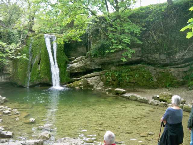
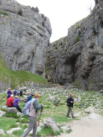
Following a further very enjoyable evening meal and hearty breakfast we again set off for a walk up to the waterfalls of Janet’s Foss and Gordale Scar. Due to the recent dry spell, neither was in full flow but still a delight.
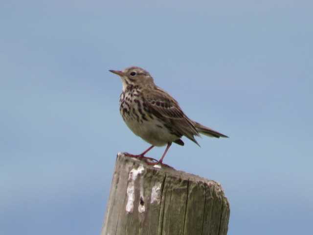
A path contouring the hillside then took us to the top of Malham Cove and our lunch stop. We were very fortunate to spot the Peregrine Falcons and their chicks on the rocks. A number of excellent photographs being taken by our “birder” Brian.
There then followed a traverse of the limestone payment and a descent of the 400 steps to the bottom of the cove.
With tired legs the walk of 5 miles was completed with a return to Malham just before the first spots of rain arrived.


A very enjoyable 3 days, and a very big thanks to all who attended especially Anne for arranging the accommodation.
More photos: https://goo.gl/photos/dhNQxWqgYy6Tm5ja7
Helena & Terry, Walk Leaders
14th May 2017
Grenoside village – Wharncliffe Wood – Wharncliffe Chase – Wheata Woods – The Chase – Wharncliffe Wood – Prior Royd – Grenoside village
This walk of around 5.5 miles was mainly on forestry tracks through the beautiful Wharncliffe Wood with a short section across open land at Wharncliffe Chase before a final climb to the impressive viewpoint above Hunter House farm. The walk started from the changed starting point of the community centre in Grenoside village for which permission had been sought from the centre’s secretary.
Heading out of Grenoside, the 16 walkers first followed the gently ascending Trans Pennine Trail route through Wheata Woods with long distance views opening up over the valley towards Oughtibridge. The clear forestry track skirted the edge of the woods before reaching the boundary with the open ground of the Chase, an area of bracken and heath with small ponds and large boulders strewn haphazardly. The high ladder stile into the Chase proved a good test of the group’s nimbleness and head for heights and was successfully tackled with some hilarity and trepidation but, thankfully, without physical injury. To rest from this exertion, the group took a short coffee break, sitting on some of the boulders and taking advantage of the great views of the moors towards Bradfield and Strines.


The next section of the route was easy walking through Wharncliffe Wood and the woodland of Prior Royd, enjoying the sunny and clear weather. The route then followed a narrow and steep path through the woods to the viewpoint above Hunter House Farm. From here, there were impressive sights in all directions, taking in Sheffield and Rotherham and the countryside in between. From this lofty perch, it was also easy to see an approaching rain cloud which fortunately dampened the opposite side of the valley rather than our group. Although we escaped the rain, we were all treated to blasts of cold wind for a short time whilst we were taking our lunch. Soon, in sunshine again, we continued our walk, heading downhill to reach our cars back in the village of Grenoside.
Ken Whetter
25th April 2017
Ford – Plumbley – West Mosborough – Moss Valley
Despite a forecast of wintry weather there was an excellent turnout of 21 members in the car park adjacent to the Bridge Inn at Ford. It was cool, but the sun was shining as we set off up a steep but short incline towards Ridgeway. The path followed a bridleway and then climbed through a large meadow, we were rewarded with lovely views over the Moss valley and across Derbyshire. Downhill now, through a sea of yellow, a field of oil seed rape, to the farm at Plumbley.
After a few more fields and stiles we arrived at our coffee/lunch stop, this had the advantage of conveniently placed large stones to sit on, excellent views and a very interesting installation, which told some of the history of Mosborough and enabled us to identify various local landmarks. Even better the sun was still shining!

After suitable refreshment, we continued our walk along the ancient trackway of Bridle Stile, into Mosborough. Some road walking down the quiet Gashouse Lane, until we turned into the Ladybank Wood, where we were greeted by a wonderful display of bluebells. We continued along Lady Ida’s Drive enjoying the sight and smell of the bluebells and fresh green leaves of the trees. Then, with a few more undulations and stiles, made our way back to the starting point. A very pleasant walk of just over 5 miles, we had sun almost all the time and only an odd hailstone or two.
Some of us completed the outing by enjoying a drink and some food at the Bridge Inn.
Marion Brassington
9th April 2017
Carlton Lees – Derwent Valley – Rowsley – Falling Edge – Falling Woods – Beeley
A warm sunny summers day in the first week of April(!), greeted 23 members on our arrival at Chatsworth Park’s Carlton Lees car park for our latest walk.
Starting with a stroll through the pretty hamlet of Carton Lees we soon entered riverside meadows to walk down the Derwent Valley to arrive at Rowsley. Just like Todwick the pronunciation of Rowsley is open to interpretation, but the locals pronounce the Row as in rowing boat.
A brief rest was taken to allow the walkers to use the facilities at Peak Village shopping centre, some also taking advantage of the “naughty but nice” cakes on sale. In the middle of the new buildings of the shopping centre stands the original railway station designed by Sir Joseph Paxton, although this was never used. When the railway from Derby to Manchester was projected in 1849 it was intended to continue in the Derwent Valley through Chatsworth Park; however, the line only reached this station. On the death of the 6th duke of Devonshire, the new Duke was not in favour of the line, so this was abandoned with the line proceeding up the Wye Valley to Bakewell. A new station, Rowsley South, being built on the other side of the A6.
A climb from Rowsley to Falling Edge was broken by taking a refreshment stop part way up the first field, giving good views of Rowsley and the Derwent Valley.
Passing through Falling Woods, where the first bluebells were seen to be coming in flower, we emerged into fields taking our second break looking down on the village of Beeley.
Passing through the very popular village, we soon crossed the road to gain the field path back to our starting point.
Terry Calladine
28th March 2017
Manor Heritage Trail Sheffield – St Aidan’s Church – City Road Cemetery – Belgian Memorial – Mass Grave World War II – Soldiers War Graves Memorial – Manor Fields – Rhubarb Shed Café – Manor Castle Hunting Lodge – Sky Edge – Shrewsbury Hospital Estate on Norfolk Road – 1832 Cholera Monument – Clay Wood – Norfolk Park
23 Todwick Ramblers assembled near St Aidan’s Church to follow the Manor Heritage Trail. A stroll through City Road Cemetery included visiting the memorial to Belgian soldiers and refugees who died in Sheffield during WW1, the mass grave of 134 Sheffielders killed in the Blitz of December 1940 and the War Graves memorial for soldiers who died of their injuries WWI & WWII.
We continued through the parkland of Manor Fields eventually reaching the Rhubarb Shed cafe where we enjoyed a coffee break and misty views across the Don valley.
Next we skirted the nearby Manor Castle Hunting Lodge, the site of Mary Queen of Scots imprisonment. We then crossed Sky Edge, by which time the mist was clearing giving extensive views over the Sheaf Valley, City Centre and the Don Valley towards Rotherham.
Walking down to see the historic Shrewsbury Hospital Estate on Norfolk Road, we had a fortuitous meeting with the Chaplain who welcomed us into the Chapel and regaled us with the history of the Estate.


We crossed to the Cholera grounds and had a short break by the Monument to commemorate the many deaths from the 1832 epidemic, another good viewing spot over the city.
A stroll through adjacent Clay Wood brought us to Norfolk Park and a walk through an avenue of Oak trees brought us to the top of the park and then back to our starting point.
We reached the end of the Ramble, somewhat weary but having learnt a little more of Sheffield’s historic past.
Brian Chambers
12th March 2017
Lees Bottom Peak Park Car Park – Deepdale – Sheldon – Great Shacklow Wood – Deepdale
We met at the Lees Bottom Peak Park Car Park just north of Ashford in the Water. Although the weather forecast had been very poor, we were blessed with a sunny and relatively warm day. Driving up the A6 to the car park it was noted that the River Wye was very high and clearly there had been a lot of rain just prior our visit. This became more apparent as the path leading up to Deepdale was submerged beneath a stream and we had to make a diversion to get to the stile at the entrance to the dale. From here we had a steady climb about 1.5 miles though Deepdale before emerging at its head. Deepdale is an area of special scientific interest due to the abundance of wildflowers that bloom from June to September. Unfortunately, we were too early to witness this display.
Emerging at the head of the dale we headed east along a minor road which after another 1.5 miles took us to the delightful village of Sheldon typical of the peak district with its stone houses, four farms, a single pub the Cock and Pullet and a village hall. We descended gently east to the edge of the village where we took a path across grassy fields northwards heading back to the River Wye. A lunch break was taken on the banks of the Wye before heading west towards our starting point.
The path now followed the banks of the river to where we came across an old water mill now, alas, gradually decaying. From here we ascended up into Great Shacklow Wood eventually dropping back to the entrance of Deepdale and hence to the car park. After a beautiful day, with not an insignificant amount of up and down, 13 tired but happy ramblers set out for home.
22nd February 2017
Broomhead Reservoir – Wigtwizzle Bridleway – Broomhead and More Hall Reservoirs
14 walkers met at Broomhead Reservoir near Bolsterstone on this windiest of days for a walk in what has been described as the “most beautiful dale in South Yorkshire”.
The initial climb, up the Wigtwizzle Bridleway, was quite steep but at least we were sheltered from the wind by trees. After a little road walking we crossed the grounds of the, now demolished, Moorhead Hall, where Guy Gibson stayed during the practice runs for the Dambusters raids (Moorhead Reservoir was one of the practice dams).


We then walked some of the Tour de France route (get your bid in if you want billiard table roads!) for a while before descending back towards the Broomhead and More Hall reservoirs, opened in 1929, designed by Mr William Terrey, probably the best water engineer in the UK and responsible for the quality of Sheffield’s water ever since. A stroll along the side of the reservoir soon took us back to the cars. A testing walk but the wind did create 14 new hairstyles!
Nige and Jude Singleton
11th February 2017
Todwick – Anston Stones Wood – Woodsetts – Todwick
The weather over the weekend commencing Saturday, 11th February 2017 was depressing, with strong easterly winds which kept temperatures throughout the daylight hours to around zero. This was coupled with continuous rain and sleet that had turned field paths into slushy wet streams, a situation that would have deterred many a walker, but not 19 members of Todwick Ramblers Club who set off on the Sunday morning for a 4.5-mile circular ramble that encompassed the pleasant and varied countryside between Anston Stones Wood and Woodsetts.


Stopping only for a short break to enjoy hot drinks from our flasks we completed the day’s outing in just under 2.5 hours with everyone saying, as we neared the end of our journey, how much they had enjoyed the experience, thus proving once again, that a day out in the fresh air with good company is a sure way to overcome damp spirits.
28th January 2017
Clumber Park – Hardwick Village – Californian Giant Redwood trees
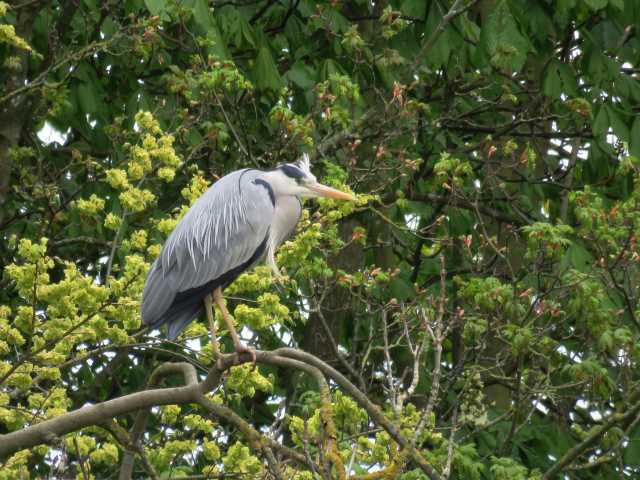
On Saturday, 28th January, 27 walkers met at Clumber Park to walk a figure-of-eight from the cricket field. The first loop of approximately 4 miles took us northwards through beautiful woodland, circling around to Hardwick Village and the eastern end of the lake. We followed the edge of the lake round to the pleasure gardens, on the way spotting a pair of herons. A stroll through the gardens completed the first loop and lunch near the main facilities.
The second, 3 mile, loop took us westwards, close to the edge of the park, following a metalled track built during WW2. On either side of the track we could make out depressions in the ground which had been ammunition dumps. Heading back towards the end of the walk we visited a group of Californian Giant Redwood trees with their unusual soft bark.
The paths were good and the weather was kind. What more could one ask?
Nigel & Judith Singleton
11th January 2017
Tresswell Wood – Stanhope Farm – Bottom Woodbeck Farm – Tresswell village – Sheds Farm – Lee Beck
Our walk began from the parking area adjacent to Tresswell Wood. The wood is maintained by Nottinghamshire Wildlife Trust and they have created a number of easy walks in and around the wood.
We took one of these wide tracks in a southerly direction for half a mile before turning east along a muddy track where one of our number accumulated a considerable covering of the aforementioned substance. After a short time we emerged out of the wood and onto a green lane taking us south and around the wood through Stanhope Farm where we witnessed horses being trained. Our path lay across two fields to the road by Bottom Woodbeck Farm.
Two quiet country lanes led us to the outskirts of Tresswell village. Rather than enter the village we took a narrow lane north and from there onto another green lane which took us northwest to our only crossing of a muddy field. Escaping the mud we followed another green lane north and then west taking us south of Sheds Farm. From here we followed Lee Beck for a short distance before heading south along a path at the edge of a field back to our cars.
Considering it was January it was quite a pleasant but windy day and all 15 members present enjoyed a 6-mile and relatively mud-free walk.